
Install the TCG app
how_to_install_app_on_ios
follow_along_with_video_below_to_see_how_to_install_our_site_as_web_app

Note: this_feature_currently_requires_accessing_site_using_safari
You are using an out of date browser. It may not display this or other websites correctly.
You should upgrade or use an alternative browser.
You should upgrade or use an alternative browser.
More options
Who Replied?

Oh, snow braaap not a real braaap.
You could braaap in snow
Oh, snow braaap not a real braaap.
i think snow braaaap was first braaap.

my grandparents live in ironwood, might call and inquire about the POW
I bet there are tons of Freshies up there now. It is probably great for the carbides and hyfax LOL.


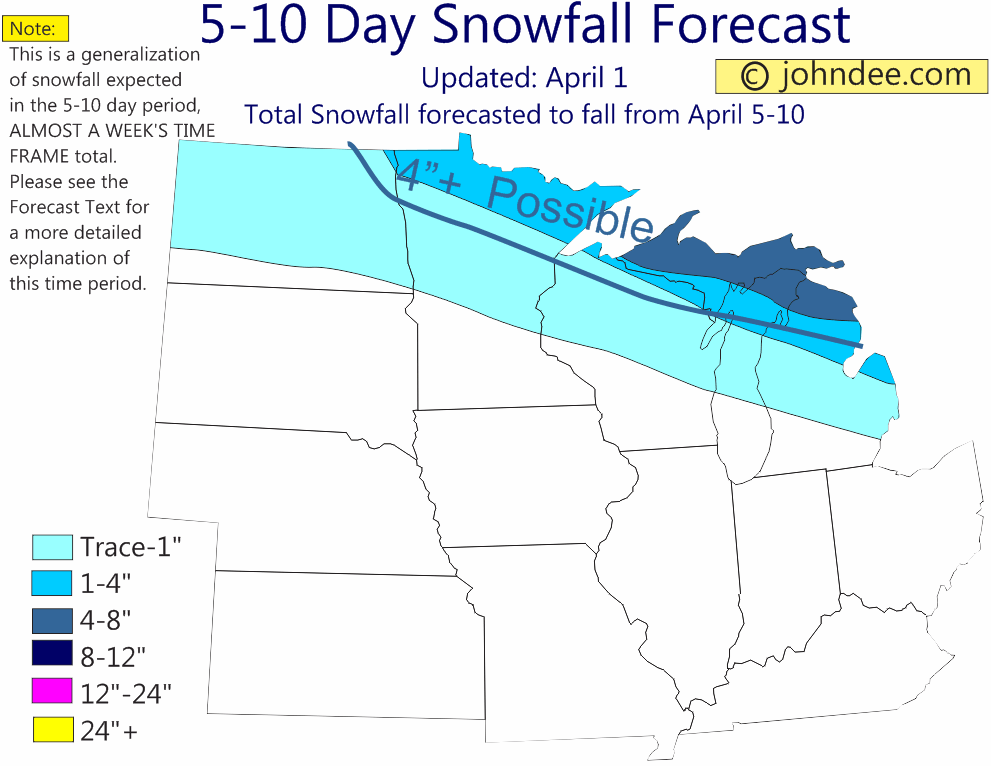
5-10 DAY FORECAST:
An area of low pressure tracking across the US/Canadian border later Thursday into Friday will bring chances for some snows to northern MN, northern WI and most of the UP. The heaviest totals look to fall across north central MN, where 3-6” is likely. Amounts elsewhere look to be in the 1-4” range.
By later in the weekend and early next week, the models all indicate another low to develop in the southern Plains and track into the Midwest. This is the textbook winter storm scenario for areas to the NW of the lows track and the models do indicate the potential for some moderate to heavy snows to fall in portions of the NW Midwest.
While I would like to etch the actual occurrence of the low in stone, I cannot do that just yet, but am giving it about a 70% chance of happening, which is a pretty high number for something that is 7 days out in the forecast.
As far as the track of the low and exact placement of the heaviest snow, that is much more up for grabs. One idea is for it to occur from eastern IA into central and NE WI and the western 2/3rds of the UP. The other idea calls for the heaviest snow to fall from northeast NE into SE SD, the SE ½ of MN, the NW 1/3rd of WI and the western 1/3rd to ½ of the UP. Maximum totals with either scenario would put some double digit accumulations in the area of heaviest snow.
So on the map, I have a rather large area outlined within a dark blue line that could see accumulations of 8-12”+, but am not saying that ALL areas within that blue line would see such amounts. The areas shaded are where I think there is a good potential for at least 1-4” of snow.
Temps would remain mild to the east of the low, with readings falling to average on the west side of the low. All of the region would then cool to average in the wake of the low and perhaps be cold enough for some LES in the UP and NWL MI snow belts, although huge LES accumulations are not seen at this point.
-John
Thread Info
-
 Created
 -
108Replies
-
4KViews
-
Participants list